Warenkorb
Sie haben keine Produkte im Warenkorb.
選択いただいた言語では、一部のコンテンツが提供されておりません。レーティッシュ鉄道の世界全体を体験したいと思われませんか? 英語に移動してください。
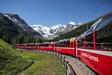
The 385 km-long track network of the Rhaetian Railway also generates some fascinating and impressive figures: One third of the network is more than 1,500 metres above sea level. One third of the RhB network has UNESCO World Heritage status. One fifth of its lines pass through or over a feat of civil engineering. More than ninety percent of the track network dates from before 1914.

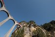
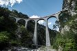
The 285 metres of the Langwieser Viaduct make it the longest structure of its type on the RhB.
| The RhB's infrastructure in figures | |
|---|---|
| Track length Proportion of civil-engineering structures to track Number of halts and stations | 385 km 20 % 102 |
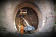
| Tunnels Longest tunnel (Vereina) Total tunnel length Proportion to track length | 115 19,042 m 58,869 m 15 % |
| Cuttings Longest cutting (Sassal Mason II) Total length of cuttings Proportion to track length | 45 348 m 3,795 m 1 % |
| Bridges Longest bridge (Langwieser Viaduct) Highest bridge (Wiesner Viaduct) Total length of bridges Proportion to track length | 606 285 m 89 m 16,411 m 4 % |
| Steepest incline (Bernina Line) Highest point (Ospizio Bernina) Lowest point (Tirano) Track gauge | 70 ‰ 2,253 m a.s.l. 429 m a.s.l. 1,000 mm |

Ospizio Bernina on Lake Bianco is, at 2,253 metres above sea level, the highest point on the RhB track network.